
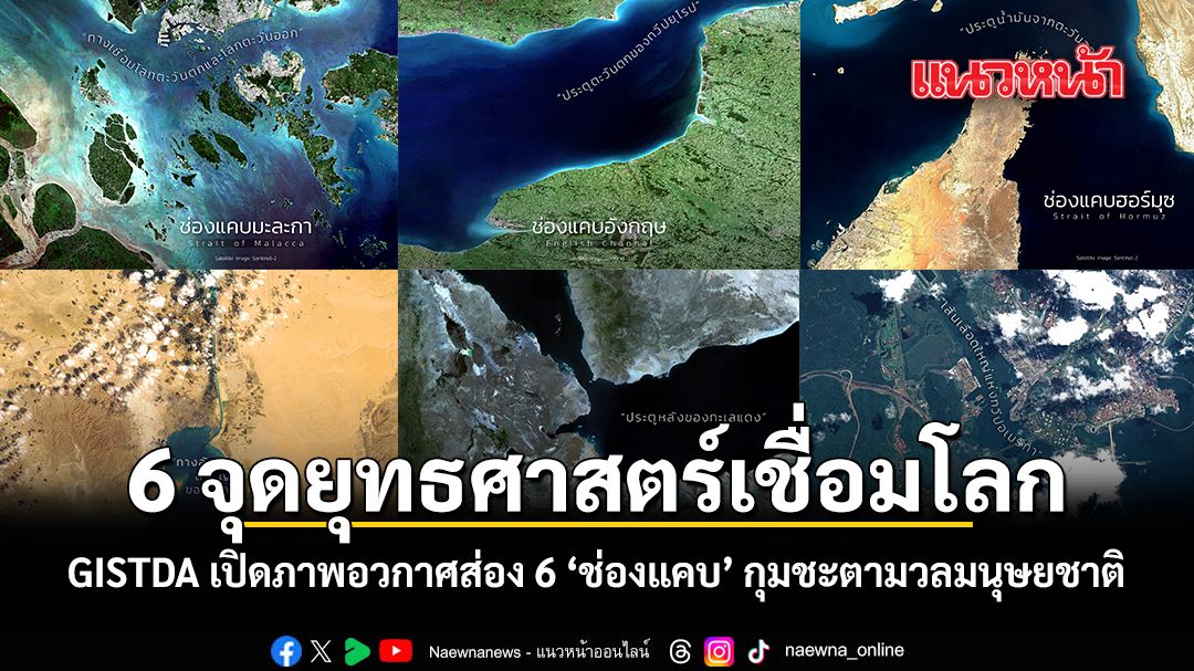


วานนี้ 27 มีนาคม 2569 GISTDA สำนักงานพัฒนาเทคโนโลยีอวกาศและภูมิสารสนเทศ (องค์การมหาชน) เปิดภาพถ่ายดาวเทียมสุดว้าว พาทุกคนไปสำรวจ 6 ช่องแคบและคลองขุดสำคัญของโลก ที่ไม่ใช่แค่ทางน้ำธรรมดา แต่คือ จุดยุทธศาสตร์ ที่ส่งผลกระทบต่อราคาน้ำมันและสินค้าในกระเป๋าตังค์ของเราโดยตรง ผ่านเพจเฟซบุ๊กโดยมีข้อความทั้งฉบับภาษาไทยและภาษาอังกฤษระบุว่า "รอยต่อทางภูมิประเทศ: จาก “ช่องแคบ”' ธรรมชาติ สู่เส้นเลือดใหญ่ทางภูมิศาสตร์ที่เชื่อมโลก สำรวจ 6 ช่องแคบสำคัญผ่านดวงตาจากอวกาศ
ช่องแคบเป็นเหมือน "เส้นเลือดใหญ่" การค้าโลก แม้จะเป็นเพียงพื้นที่เส้นทางน้ำ แต่ความสำคัญของมันนั้นมหาศาลทั้งในเชิงเศรษฐกิจ การเมืองและความมั่นคง เป็นทางลัดช่วยลดระยะเวลาประหยัดต้นทุนพลังงานการขนส่ง เป็นต้น ถือเป็นหนึ่งเครื่องมือทางภูมิศาสตร์ที่ถูกสร้างโดยธรรมชาติ แต่เป็นกลไกควบคุมทางเศรษฐกิจของทั้งโลกได้ เนื่องจากเป็นเส้นทางเชื่อมโลกมาตั้งแต่อดีตจนถึงปัจจุบัน
.jpg)
ช่องแคบ (Strait) “สเตรท” ลักษณะภูมิประเทศที่เป็นพื้นที่ทางทะเลทอดอยู่ระหว่าง 2 พื้นทวีปหรือเกาะ โดยในบางแห่งช่องแคบเป็นจุดเชื่อมรอยต่อของมหาสมุทร สาเหตุนี้ทำให้ช่องแคบเป็นพื้นที่ทรงอิทธิพลต่อภูมิรัฐศาสตร์ของโลก เพราะมีผลต่อปัจจัยเชิงพื้นที่ อีกทั้งได้รับปัจจัยจากมนุษย์ที่กำหนดนโยบายทางทะเล การสัญจรทางทะเลมีมาตั้งแต่อดีตเพราะเรือสามารถบรรทุกสิ่งของได้มากทั้งสินค้าอุปโภค บริโภค รวมถึงพลังงานธรรมชาติ เช่น น้ำมัน ก๊าซธรรมชาติ และแร่ธาตุสำคัญต่างๆ ในภาคอุตสาหกรรม เป็นต้น วันนี้แอดมินจะพาไปสำรวจ 6 ช่องแคบสำคัญผ่านดวงตาจากอวกาศ ซึ่งถือเป็นยุทธศาสตร์ที่สำคัญของโลกกันครับ
ช่องแคบฮอร์มุซ “ประตูน้ำมันจากตะวันออกกลาง” ตั้งอยู่ทวีปเอเชียคั่นระหว่างแหลมมุซันดัม ประเทศโอมาน สหรัฐอาหรับเอมิเรตส์ และอิร่าน ทำหน้าที่เชื่อมอ่าวเปอร์เซีย และอ่าวโอมานกว้างประมาณ 39 กิโลเมตรเป็นทางออกสู่มหาสมุทรอินเดียทางเดียวของกลุ่มประเทศผู้ค้าน้ำมันในเอเชียตะวันตกเฉียงใต้ (ตะวันออกกลาง) โดยเฉลี่ย 1 วันมีเรือบรรทุกน้ำมันประมาณ 17 ล้านบาร์เรล คิดเป็น 20% ของปริมาณน้ำมันโลก ยังมีการส่งออกก๊าซธรรมชาติเหลว คิดเป็น 1 ใน 4 ของโลกทำให้ช่องแคบฮอร์มุซมีผลต่อความมั่นคงด้านพลังงาน โดยเฉพาะประเทศที่พึ่งพาพลังงานจากกลุ่มประเทศอาหรับ ในทวีปเอเชียจะได้รับผลกระทบโดยตรง และประเทศไทยเองพึ่งพาน้ำมันกว่า 50% ทั้งนี้ ด้วยสถานการณ์ในปัจจุบันได้สร้างผลกระทบต่อเศรษฐกิจไทยทำให้ต้นทุนด้านพลังงานสูงขึ้นจากการขนส่งทางทะเล
.jpg)
ช่องแคบอังกฤษ “ประตูตะวันตกของทวีปยุโรป” ตั้งอยู่ทวีปยุโรปคั่นระหว่างประเทศอังกฤษ และประเทศฝรั่งเศส ทำหน้าที่เชื่อมต่อทะเลเหนือและมหาสมุทรแอตแลนติก อีกทั้งเป็นเส้นทางเชื่อมเกาะบริเตนใหญ่และแผ่นดินใหญ่ของยุโรป ส่วนที่แคบที่สุดอยู่บริเวณช่องแคบโดเวอร์มีความกว้างที่ 34 กิโลเมตร ช่องแคบอังกฤษมีความสำคัญมาตั้งแต่อดีต เป็นเส้นทางเชื่อมต่อไปยังอเมริกาผ่านมหาสมุทรแอตแลนติก ปัจจุบันถือเป็นช่องแคบที่มีเรือสัญจรมากที่สุดในโลก รองรับเรือประมาณ 500 ลำต่อวัน โดยการสัญจรในบริเวณนี้ต้องอาศัยความชำนาญ รวมถึงความระมัดระวังเพราะสภาพอากาศที่แปรปรวน คลื่นลมแรง และแรงดันน้ำสูง มีผลมาจากภูมิประเทศที่ตั้งอยู่ในมหาสมุทรแอตแลนติกประกอบกับกระแสน้ำอุ่นก่อให้เกิดความชื้น รวมถึงลมตะวันตกทำให้เกิดฝน อีกทั้งชายฝั่งยุโรปบริเวณช่องแคบอังกฤษถือเป็นแหล่งเพาะปลูกที่สำคัญ
.jpg)
ช่องแคบมะละกา “ทางเชื่อมโลกตะวันตกและโลกตะวันออก” ตั้งอยู่ทวีปเอเชียบริเวณคาบสมุทรมลายูคั่นระหว่างเกาะสุมาตรา ทำหน้าที่เชื่อมทะเลจีนใต้ มหาสมุทรแปซิฟิกและมหาสมุทรอินเดีย ส่วนที่แคบที่สุดมีความกว้างที่ 2.7 กิโลเมตร อีกทั้งยังเป็นทางผ่านของการขนส่งสินค้าทางทะเลที่มีความสำคัญต่อประเทศไทย ถือเป็นช่องแคบยุทธศาสตร์ด้านภูมิรัฐศาสตร์ รวมถึงด้านเศรษฐกิจของเอเชียตะวันออกและตะวันออกเฉียงใต้ เพราะเป็นเส้นทางที่มีการสัญจรทางทะเลหนาแน่นเป็นอันดับ 2 ของโลก รองรับเรือเกือบ 100,000 ลำต่อปี และเป็นเส้นทางการลำเลียงน้ำมันถึง 35% ของโลก รวมถึงก๊าซธรรมชาติจากกลุ่มประเทศอาหรับ ช่องแคบมะละกามีท่าเรือสำคัญตั้งอยู่หลายแห่ง เช่น ท่าเรือสิงคโปร์ ท่าเรือพอร์ตกลัง และท่าเรือมะละกา และเป็นศูนย์กลางที่เชื่อมตลาดประเทศฝั่งเอเชียเข้ากับยุโรป
.jpg)
ช่องแคบบับเอลมันเดบ “ประตูหลังของทะเลแดง” ตั้งอยู่รอยต่อระหว่างทวีปแอฟริกาและเอเชีย คั่นกลางระหว่างประเทศจิบูตี เอริเธีย และเยเมนส่วนที่แคบที่สุดกว้างประมาณ 26 เมตร ทำหน้าที่เชื่อมทะเลเมดิเตอเรเนียน ทะเลแดงออกสู่ทะเลอาหรับผ่านคลองที่ขุดขึ้นอย่างคลองสุเอซ เมื่อมีการขุดคลองสุเอซทำให้ช่องแคบแห่งนี้มีเรือสัญจรมากขึ้น เนื่องจากกลายเป็นประตูกลายเป็นด่านแรกในการขนส่งสินค้าจากทวีปเอเชียสู่ทวีปยุโรป โดยเฉลี่ย 1 วันมีเรือบรรทุกน้ำมันจากกลุ่มประเทศอาหรับประมาณ 6-8 ล้านบาร์เรล รวมถึงสินค้าอื่น ๆ ผ่านช่องแคบนี้ ทำให้ช่องแคบบับเอลมันเดบหากถูกควบคุมคลองสุเอซจะหยุดชะงักโดยทันที
.jpg)
คลองสุเอซ “ทางลัดสำคัญของโลก” ตั้งอยู่ประเทศอียิบต์ ซึ่งมีจุดเริ่มต้นที่พอร์ตซาอิตและสิ้นสุดที่พอร์ตสุเอซ ถือเป็นอีกหนึ่งคลองที่ถูกมนุษย์สร้างขึ้น มีความยาว 193.3 กิโลเมตร ซึ่งเป็นคลองขุดโดยมนุษย์ที่ยาวที่สุดในโลก มีความกว้าง 300-350 เมตร โดยขุดครั้งแรกปี 1859 ใช้เวลาขุด 10 ปี ก่อนเปิดให้บริการปี 1869 อยู่ระหว่างทวีปแอฟริกากับเอเชีย ทำหน้าที่เชื่อมมหาสมุทรแอตแลนติกและมหาสมุทรอินเดียผ่านทะเลเมดิเตอร์เรเนียนกับทะเลแดง คลองสุเอซช่วยลดระยะทางจากการอ้อมทวีปแอฟริกาบริเวณแหมกู๊ดโฮปที่เดิมใช้เวลา 8-10 วัน เหลือเพียง 11-16 ชั่วโมง โดยคลองสุเอซรองรับเรือประมาณ 25,000 ลำต่อปี คิดเป็น 12-14% ของการค้าโลก เป็นเส้นทางหลักในการขนส่งน้ำมัน ก๊าซธรรมชาติ รวมถึงสินค้าอุปโภคและบริโภคของทวีปยุโรป
.jpg)
คลองปานามา “เส้นเลือดใหญ่แห่งทวีปอเมริกา” ตั้งอยู่บริเวณตอนกลางของประเทศปานามาในอเมริกากลาง ทำหน้าที่เชื่อมมหาสมุทรแอตแลนติกและมหาสมุทรแปซิฟิกฝั่งตะวันออก มีความยาว 82 กิโลเมตร มีความกว้างน้อยที่สุด 91 เมตร โดยขุดครั้งแรกปี 1904 ก่อนแล้วเสร็จปี 1914 คลองปานามาช่วยลดระยะทางอ้อมทวีปอเมริกาใต้บริเวณแหลมฮอร์น เดิมใช้เวลาเกือบ 2 สัปดาห์ เหลือเพียง 10 ชั่วโมง โดยเป็นโครงการที่ท้าทายด้านวิศวกรรม รวมถึงการก่อสร้าง เนื่องด้วยการออกแบบและสร้างประตูกั้นน้ำถึง 12 ประตูเพื่อปรับระดับน้ำสำหรับการเดินเรือที่มีความแตกต่างของ 2 มหาสมุทร ทุกปีคลองปานามารองรับเรือเกือบ 15,000 ลำ สำหรับการขนส่งสินค้า เช่น รถยนต์ และพลังงานธรรมชาติของทวีปอเมริกา
.jpg)
เมื่อช่องแคบเหล่านี้คือ “เส้นเลือดใหญ่” ที่หล่อเลี้ยงเศรษฐกิจโลก การดูแลความปลอดภัยของเรือนับแสนลำจึงต้องอาศัยวิสัยทัศน์ที่กว้างไกลกว่าเดิม ปัจจุบันเทคโนโลยีอวกาศจึงเข้ามามีบทบาทสำคัญในการจัดการจราจรทางทะเล
ดาวเทียมในปัจจุบันไม่ได้ทำหน้าที่แค่ถ่ายภาพพื้นผิวโลก แต่ยังใช้คลื่นสัญญาณส่งลงมากระทบวัตถุบนผิวน้ำเพื่อสะท้อนกลับ ทำให้เราสามารถติดตามการเคลื่อนไหวและระบุพิกัดของเรือสินค้าต่างๆ ได้แบบ เรียลไทม์ เทคโนโลยีอวกาศจึงเปรียบเสมือน “ดวงตา” ที่คอยสอดส่องและควบคุมความปลอดภัย ยกระดับการสัญจรทางทะเลของโลกให้ราบรื่นและมีประสิทธิภาพมากยิ่งขึ้น
__________
Geographic Arteries: A Satellite Perspective on the Six Straits That Define Global Commerce.
From natural straits to vital arteries of global trade, these geographical junctions connect the world. This study examines six significant straits from a space-based perspective.
.jpg)
Far more than mere waterways, the world’s primary straits function as the indispensable arteries of global commerce. These natural conduits serve as high-stakes geopolitical levers, offering critical shortcuts that drastically reduce transit times and fuel consumption. While carved by nature, they operate as a man-made mechanism for economic dominance, remaining the most vital links in the global supply chain from antiquity to the modern era.
A strait is a vital geographical feature — a narrow body of water that lies between two continents or islands. In many cases, straits serve as critical links between major oceans, elevating their importance in global geopolitics. These waterways shape not only physical geography but also maritime policies driven by human activity. Maritime navigation has existed since ancient times, as ships offer an efficient means of transporting large volumes of goods—from everyday consumer products to natural resources such as oil, natural gas, and essential industrial minerals. Today, we explore six of the world’s most strategically significant straits through a space-based perspective, revealing their crucial role in shaping global trade, security, and connectivity.
The Strait of Hormuz, “The Strategic Maritime Gateways” — Situated between the rugged cliffs of Oman’s Cape Musandam and the Iranian coastline, the Strait of Hormuz remains the world’s most sensitive maritime artery. As the sole exit for Persian Gulf crude, this narrow passage facilitates the transit of 17 million barrels daily—accounting for 20% of global oil supply and a quarter of worldwide LNG exports. For energy-dependent nations like Thailand, which relies on the Middle East for over 50% of its oil, the strait is more than a geographic landmark; it is a critical vulnerability. Current regional tensions are already manifesting in the Thai economy through surging logistics costs and heightened energy inflation.
The English Channel, “the Western Gateway of Europe” — located in Europe, serves as a natural boundary separating England and France. It connects the North Sea with the Atlantic Ocean and functions as a key maritime route linking Great Britain to the European mainland. Its narrowest point, the Dover Strait, spans just 34 kilometers wide. Historically, the English Channel has played a significant role as a gateway to the Americas via the Atlantic Ocean. Today, it holds the title of the world's busiest strait, handling approximately 500 vessels per day. However, navigation through this waterway demands considerable skill and caution. Mariners must contend with unpredictable weather conditions, strong winds, and powerful water currents — challenges that stem from its position in the Atlantic Ocean, where warm ocean currents bring high humidity and prevailing westerly winds generate frequent rainfall. Beyond its maritime significance, the European coastline along the English Channel is also recognized as a vital agricultural region, contributing to the economic importance of the area on both sides of the strait.
The Strait of Malacca, “the Gateway Between East and West” — a vital waterway located in Asia along the Malay Peninsula, separating it from the Indonesian island of Sumatra. The strait serves as a critical connection between the South China Sea, the Pacific Ocean, and the Indian Ocean, with its narrowest point measuring just 2.7 kilometers wide. The waterway holds immense strategic importance — both geopolitically and economically — for East and Southeast Asia, including Thailand, where it serves as a key maritime shipping corridor. It ranks as the second busiest shipping lane in the world, handling nearly 100,000 vessels annually. The strait also carries approximately 35% of the world's oil shipments, along with significant volumes of natural gas from Arab nations. Several major ports are situated along the strait, including the Port of Singapore, Port Klang, and the Port of Malacca, cementing its role as a central hub connecting Asian markets with Europe.
The Bab-el-Mandeb Strait, “the Back Door of the Red Sea” — a critical maritime corridor at the intersection of Africa and Asia. Separating Djibouti and Eritrea from Yemen, this narrow passage—spanning roughly 26 kilometers at its tightest point—serves as the indispensable link between the Mediterranean and the Arabian Sea. Since the Suez Canal’s inception, the strait has evolved into a global trade artery, facilitating the daily transit of 6 to 8 million barrels of oil and vast quantities of dry cargo. Its strategic value is absolute: any disruption to the Bab el-Mandeb would effectively paralyze the Suez Canal, severing the primary energy and trade lifeline between Asia and Europe.
The Suez Canal, “the World’s Vital Shortcut” — spanning 193.3 kilometers across the Egyptian desert, the Suez Canal remains the world’s longest man-made waterway and a cornerstone of global logistics. Stretching from Port Said to Port Suez, this 350-meter-wide "shortcut" serves as the ultimate bridge between Africa and Asia. By linking the Mediterranean and Red Seas, the canal offers a direct passage between the Atlantic and Indian Oceans, slashing transit times from 10 days—the traditional route via the Cape of Good Hope—to a mere 11 to 16 hours. Today, the canal facilitates 12-14% of global trade, with approximately 25,000 vessels annually hauling essential oil, natural gas, and consumer goods to Western markets.
The Panama Canal, “the Lifeblood of the Americas” — serving as the primary maritime artery of the Western Hemisphere, the Panama Canal remains a cornerstone of global trade. Stretching 82 kilometers across Central Panama, this engineering marvel links the Atlantic and Pacific Oceans, effectively bypassing the perilous Cape Horn. By utilizing a sophisticated system of 12 locks to navigate varying water levels, the canal slashes transit times from nearly two weeks to a mere 10 hours. Today, it facilitates the passage of approximately 15,000 vessels annually, funneling essential commodities and automobiles across the globe.
As the primary lifelines of the global economy, these straits demand unprecedented oversight. With hundreds of thousands of vessels navigating these narrow corridors, space-based surveillance has shifted from a luxury to a necessity in securing modern maritime traffic.
Beyond mere imagery, modern satellites are leveraging advanced signal reflection to track cargo vessels in real-time. This orbital surveillance serves as a digital 'eye' in the sky, optimizing maritime traffic flow and bolstering global supply chain security.
#GISTDA #อว #ช่องแคบ #ภาพถ่ายดาวเทียม "
.jpg)
.jpg)
.jpg)
.jpg)
.jpg)
ขอขอบคุณข้อมูลและภาพจาก เฟซบุ๊ก GISTDA สำนักงานพัฒนาเทคโนโลยีอวกาศและภูมิสารสนเทศ (องค์การมหาชน)
โปรดอ่านก่อนแสดงความคิดเห็น
1.กรุณาใช้ถ้อยคำที่ สุภาพ เหมาะสม ไม่ใช้ ถ้อยคำหยาบคาย ดูหมิ่น ส่อเสียด ให้ร้ายผู้อื่น สร้างความแตกแยกในสังคม งดการใช้ถ้อยคำที่ดูหมิ่นหรือยุยงให้เกลียดชังสถาบันชาติ ศาสนา พระมหากษัตริย์
2.หากพบข้อความที่ไม่เหมาะสม สามารถแจ้งได้ที่อีเมล์ online@naewna.com โดยทีมงานและผู้จัดทำเว็บไซด์ www.naewna.com ขอสงวนสิทธิ์ในการลบความคิดเห็นที่พิจารณาแล้วว่าไม่เหมาะสม โดยไม่ต้องชี้แจงเหตุผลใดๆ ทุกกรณี
3.ขอบเขตความรับผิดชอบของทีมงานและผู้ดำเนินการจัดทำเว็บไซด์ อยู่ที่เนื้อหาข่าวสารที่นำเสนอเท่านั้น หากมีข้อความหรือความคิดเห็นใดที่ขัดต่อข้อ 1 ถือว่าเป็นกระทำนอกเหนือเจตนาของทีมงานและผู้ดำเนินการจัดทำเว็บไซด์ และไม่เป็นเหตุอันต้องรับผิดทางกฎหมายในทุกกรณี